Thursday, February 24, 2011

Storm Sinking South...Metro Out of Advisory


The winter weather advisory has been updated to take Dallas, Polk and Tama Counties out of the advisory area.
The snow is staying south of Interstate 80. It was amazing to see how much snow was falling just south of the metro through the evening.
New Virginia...in Warren County...about 20 minutes south of Des Moines received 2 inches of snow in just 45 minutes tonight. Pella reported 3 inches of snow by 7 PM. Murray in Clarke County had 4.4 inches as of 8:00 tonight.
Roads are 100% snow covered along the southern 2 tiers of counties.

Dry Air Holding Off Snow In Des Moines


We still have a winter weather advisory in effect for Des Moines...and a winter storm warning in south central and southeastern Iowa. Purple shaded counties are the advised areas...pink are the warned.
There is a dry north wind that has left Des Moines dry for now. Heavier snow is lining up to the south of the metro...and I do think more moisture will wrap around the storm to the south to give us snow later this evening. You can see road conditions are pretty rotten in southern Iowa.
Still going with 2" to 3" of snow here....5 to 7 inches in the southern 2-lines of counties.
Check out the forecast and updated weather information tonight at five and six...


Des Moines Metro...Winter Weather Advisory


Hello again! In the last blog I said Des Moines was not in the advisory area "yet". Well...we made it.
The new warning map shows the purple counties that now include the metro in the winter weather advisory.
The pink counties are now included in a winter storm warning.
That area of southeastern Iowa will see 5 to 8 inches of snow.
In the metro we will see widespread 2 to 3 inches of snow, but there will be pockets of heavier snow.
As I told you last night on the news at 10 PM... this storm had the potential to move slightly to the north. It is doing just that. It is moving into southern and central Missouri. It means more snow for us.
More updates coming your way this afternoon.

Update To Winter Storm

Hey folks... just a quick update for the afternoon forecast.

It looks like more snow is going to fall over southern Iowa. It looks like a winter storm warning will be issued for areas around Lamoni to Knoxville and southeast of that area.

The winter weather advisory comes right up to Des Moines...but does not include Polk County....yet.

The heavier amount of snow is expected during the evening commute....between 6 to 9 PM.

More updates through the day.

Winter Storm Today...Tonight...This Weekend


A WINTER STORM ADVISORY is in effect for much of southern and southeastern Iowa starting this afternoon and continuing through midnight.
The storm to the south is going to churn up moisture to Iowa where our cold temperatures will give us the chance for 1-3 inches of snow in the metro... 3 to 5 inches of snow in southern Iowa.
The air is too dry right now for snow accumulation in Des Moines. The snow will really start accumulating later this evening.
By 6 this evening we can expect snow in Des Moines. The last part of the evening commute could be slick.
This snow will end early tomorrow morning....but this is just the first wave of snow. The next round moves in tomorrow night and will continue through Saturday afternoon. We have the chance for another 2 to 4 inches of snow in that time period.
Sunday... there is another storm moving in for the end of the weekend that could leave the area with snow and freezing rain on Sunday. This one looks to move in during the afternoon and evening hours.
One week ago today.... we hit 70 degrees!

Tuesday, February 22, 2011

Major Miss on Major Storms This Winter

This picture may not make you believe it...but we have missed some major winter storms this year.

We have seen many of the largest Midwest storms stay to the north and the south of Des Moines.

I checked out the snow numbers for Minneapolis. So far the Twin Cities has received 65.1 inches of snow since December 1. 74.9 inches of snow since July 1 of last year.

The average snowfall for the "Cities" up to this point of winter is 40.5".

Kansas City has pushed 30.2" of snow this season. On the average K.C. sees about 16.1 inches of snow up to this point of the year.

We have had 31.5" of snow so far this year. Just a bit more than Kansas City... but way below the monster totals of Minneapolis.

Last year we outdid ourselves. Here are the totals for snowfall last year.

Des Moines ... 62.3"
Twin Cities... 37.8"
Kansas City... 35.5"

Friday, February 18, 2011

Weekend of Warmth...But Storms!


There is a winter storm watch for northern Iowa starting at 12 AM Sunday. It will be in effect until 6 AM Monday.
We will have warmer-than-average temperatures again Saturday. It will be dry through most of the day...but a storm system off the Pacific Coast will slam into the state late Saturday with rain and even thunderstorms by early Sunday morning.
The colder air moves into northern Iowa late Sunday and that is when we could see ice and snow accumulation in the northern Iowa/Southern Minnesota area.
Plan for poor driving conditions later Sunday north of Mason City.
Stay tuned through the weekend...Megan will be here to update the storm track as it gets closer to Iowa.

Thursday, February 17, 2011

Tied Record High

We tied the record high today in Des Moines. The last time the temperature was 68 in Des Moines was 1981.

The great weather did lead to some headaches along the Des Moines and Raccoon Rivers in Des Moines today. The major melting lead to some isolated flash flooding. The ice jams along some of the bridges and walk paths caused the water to overflow the river banks.

There will be some areas of re-freeze tonight as temperatures fall to the freezing point by early morning. Watch out for patches of ice tomorrow morning....then we are on our way to the upper 40s Friday. No records....but great for February.

Flash Flood Warning Update

...Flash Flood Warning for ice jam flooding remains in effect for southeastern Dallas and southwestern Polk counties until 730 PM ...

At 355 PM ...ice jamming was reported on the Raccoon river from about a mile west of the Dallas-Polk County line...downstream to fleur drive. Some locations that will experience flash flooding include...Des Moines...Pleasant Hill and West Des Moines.

The Raccoon river was fluctuating rapidly due to ice action. The river gage at Highway 28 rise 9 feet...to about 2 feet above flood stage earlier this afternoon as the ice jam moved through that area. The river state at fleur drive has risen about 5 feet by 330 PM.

Fluctuations in river levels will continue through the next several hours...with occasional breaches of the river bank as the ice hangs up.

Stay away from flooded areas. Do not let children play near the ice jams.

FLASH FLOODING...ICE JAMS ON RACCOON

...Flash Flood Warning for ice jam flooding remains in effect for southeastern Dallas and southwestern Polk counties until 730 PM.

At 247 PM ...local law enforcement officials reported that flash flooding was occurring in the Raccoon river due to ice jamming. The extent of the backup is from the walk bridge in Waterworks Park...west to about a mile west of the Dallas-Polk County line.

The river gage on Highway 28 indicated a rise of 9 feet early this afternoon to just over 34 feet. In the past hour it has fallen 4 feet to just over 30 feet...2 feet below flood stage. This indicates the ice jam may be beginning to move downstream once again.

Some locations that will experience flash flooding include...Des Moines...Pleasant Hill and West Des Moines. stay away from flooded areas. do not let children play near the ice jams. Stay away from flooded areas. Do not let children play near the ice jams.

Here We Go! 60s busting through at 11 AM


The Legacy Golf Club in Norwalk is open for golf today! Matt Manning is the owner and called me this morning to let me know they decided to open for the season.

Matt said he had to get out the skid-loader to move some snow off a few of the cart paths...and there are some piles of snow in a few of the bunkers and shaded areas.

They put the information on their web site and 20 golfers were on the links by 11 AM. The expect about 100 hackers on the course today...and will be open through the weekend.

It was already 63 degrees at 11 AM. The sun broke through by 10:30 and really started to heat us up. The south wind will continue to be gusty and help to keep us on the record hunt for the day.

The record stands at 68...set in 1981. It will fall by this afternoon.

Here are the other temperatures for the central Iowa area at 11 AM.

CENTRAL IOWA

CITY
AMES PTSUNNY 58 53 84 SW23G31 29.42S
ANKENY * PTSUNNY 61 57 88 SW18G30 29.45S
BOONE * PTSUNNY 56 52 87 SW22G29 29.43S
CHARITON * MOSUNNY 61 54 77 SW17G26 29.51R
DES MOINES CLOUDY 63 53 70 SW29G37 29.45F
GRINNELL* CLOUDY 55 54 94 S14 29.47S
KNOXVILLE * PTSUNNY 61 54 77 SW23G30 29.48S
MARSHALLTOWN PTSUNNY 57 53 86 SW15 29.43S
NEWTON * PTSUNNY 59 54 82 SW13G18 29.47S
PELLA * PTSUNNY 59 50 72 SW16G24 29.50R

Wednesday, February 16, 2011


A DENSE FOG ADVISORY is in effect until 10 AM tomorrow. Visibilities will drop under 1/4 mile at times. The fog is going to develop in southern Iowa and move to the north.
Temperatures will remain very warm tonight. Lows will stay in the middle 40s. That will give us a chance to get close to record highs on Thursday.
I expect the south wind to gust near 30 mph. It will be warm with a high of 66. The record for tomorrow is 68.
Be careful as the fog closes in tonight.
Ed

Tuesday, February 15, 2011

Warm Weather

We have a couple more days of great temperatures on the way. Highs will be in the 50s tomorrow and the lower 60s Thursday.

There will be areas of fog and drizzle tomorrow morning. There is a chance for some re-freeze again. Make sure to check your step. The sidewalks might just look wet.

It will be windy on Thursday...the south wind will gust to 30 mph and boost the highs to near-record range. The record high for Wednesday is 68. It was set in 1981.

It will be cooler Friday. Highs will be back in the reality range of upper 30s.

There is a chance for showers Sunday night into Monday. The highs will remain about 8 to 10 degrees above the average.

Tuesday, February 8, 2011

No Big Surprise...Wind Chill Advisory Again


Don't you just love the picture of Ron from Freemont, IA?
His wife sent in the picture on Ground Hog Day. Ron said if the sun was shinning he would be outside in his shorts. No one chills better than Ron.
Tonight a wind chill advisory is back in effect until Noon Wednesday. The wind will only be around 5 to 10 mph....the actual temperature will bottom out at minus 8.
Don't fall into complete despair... 40s are back at the end of our 7 Day Forecast!

Monday, February 7, 2011

Army Wives...6 Months Until Homecoming


Saturday night my wife and I were at a party for a friend at the Blue Moon Piano Bar in West Des Moines. While we were there... this group of Army wives stopped me and asked for a picture to send to their husbands who are half-way through their 12 month deployment.
Lisa Adams sent me the picture and wanted to thank me.
Ed -

Thank you so much for taking time for a photo Saturday night with our group of Army Wives~ Here's the picture. We were celebrating the 6 month milestone for this 12 month deployment. Getting this picture with you was a highlight of a very fun night!

They really are a great group of wives - strongest hearts I've ever encountered!

Thanks again,

Lisa Adams

Also Pictured:
Patty Keeley, Nicole Dornfield, Anna Fuller, Jessica Vandewater, Carroll Deets, Rana Webster

Lisa, Patty, Nicole, Anna, Jessica, Carroll and Rana were having a nice time, but I felt their anxiety. It is necessary to allow time to blow off some steam and to celebrate the half-way point until they get to be with their servicemen again. Strong women who have formed a strong bond and friendship with the only others who really know what each is going through.
I sent Lisa an email thanking her and the other Army wives for their sacrifice and the service of their husbands. It is hard for me to wrap my head around the thought of not having my wife with me for over a year. Even more unimaginable...knowing the life of the person I love the most is in danger.
We are so blessed to have Iowa wives, husbands and families who are making this sacrifice to keep our families safe and free.
Thank you so much.

WIND CHILL ADVISORY TONIGHT


Guess what... it is going to be cold tonight. There will also be a bit of wind that will drop our wind chill temperatures to -25 by early morning.
The advisory goes into effect at midnight and lasts through noon tomorrow.
There is a chance for more of the wind chill advisory maps tomorrow night...but little chance for other winter watches or warnings.
The rest of the week will be dry...and by the weekend we will start to melt away some snow. Highs by the weekend are expected to hit the 40s.
Stay warm and safe tonight.

Wednesday, February 2, 2011

Wind Chill Advisory Tonight


The snow is going to stay around for awhile....and the cold air and wind tonight will make it very cold for our state.
A WIND CHILL ADVISORY is in effect for the state. It starts at midnight in central Iowa and continues until 10 AM.

* WINDS...A NORTH WIND AT 15 TO 25 MPH WILL SWITCH TO THE WEST BY
MIDNIGHT THEN SOUTHWEST BY 6AM THURSDAY. THE WIND WILL DIMINISH
SOME THIS EVENING.

* TEMPERATURES/WIND CHILL VALUES...OVERNIGHT LOWS WILL DROP TO
BETWEEN 5 AND 10 BELOW AND COMBINED WITH THE WIND...WIND CHILL
VALUES WILL RANGE FROM 15 TO 25 BELOW THROUGH MID MORNING
THURSDAY.

* IMPACTS...THE COMBINATION OF EXTREME COLD AND STRONG WINDS WILL
RESULT IN FROSTBITE IF EXPOSURE TO OUTSIDE ELEMENTS WITHOUT
PROPER WEATHER CLOTHING LASTS FOR AN EXTENDED PERIOD OF TIME

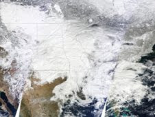
NASA Satellite Pics of Storm


Some amazing pictures from space of the storm that covered about 1/2 of the country.
The high resolution pictures are from NASA.
You can see the entire article at:


www.nasa.gov/topics/earth/features/snowstorm_feb2011.html

Big Snow Blowers


IOWA DOT REROUTING PEOPLE AND MACHINES TO SE IOWA

Engineers at the Iowa Department of Transportation have been holding conference calls Wednesday on how to get some help for southeast Iowa. Bob Younie who is the State DOT Maintenance Engineer says that this state wide storm coupled with huge amounts of snow in southeast Iowa has caused the DOT to look at sending extra help to snow bound southeastern Iowa. Hardest hit is State Highway 218, or the Avenue of the Saints.
"In southeast Iowa they had 16-17 inches of snow," said Younie, " so, what we're doing is as we finish cleaning up roads in other parts of the state, we're moving some of that equipment to southeast Iowa," he added.

Younie says they have some goals. ""We think most of the state, the non-southeast Iowa part of the state is gonna be pretty well cleaned up by the end of today," he said. Younie added, "once we get to southeast Iowa, we'd like to have it all done within 24 hours after that, that's our goal."

Iowa has 901 snow plows over the whole state covering 10,000 miles of Interstate and Primary Highways. They also have 11 heavy duty snow throwers which cost a half a million dollars each. They keep them all in the northern half of the state, as southern Iowa usually does not get heavy snow. The snow cleanup Wednesday was on highway 175 east of Ellsworth.
The road was closed due to drifting snow. The heavy duty snow thrower is headed toward Radcliffe, Eldora, and eventually Grundy Center tonight. The driver of the plow said he has a number of stretches yet to plow which have numerous cars in the middle which may have to be towed. One car was almost on highway 175 in a drift the snow thrower says he will just go around it. Thursday morning at mid night this thrower and one other will be loaded on trucks to go to SE Iowa. This unit will be sent to Muscatine.

Tuesday, February 1, 2011

Blizzard On...School Off


The blizzard conditions continue for most of central Iowa....and as of 8:00 tonight... the Des Moines public schools announced no classes for Wednesday. You can see the entire list of closings on Channel 13 right now. There is a long list.
Travel is still not recommended over most of the state. The wind speeds are hanging in there around 40 to 45 mph. Drifts over 3 to 4 feet have been reported in Centerville...that is in southern Iowa where about 8 to 9 inches of snow has fallen.

Blizzard Update


The blizzard is taking it's toll on central Iowa. The storm is bringing in more moisture from the south. Albia is reporting 4.5 inches of snow with drifts approaching 1 foot in depth.
The blizzard picture is from Missouri. The parents of one of our producers sent in the picture. It goes along with the extended line of blizzard warnings that cover Oklahoma...Missouri...Iowa..Illinois... Wisconsin...Michigan and Indiana.
The big blast of the blizzard will blow through later tonight....but I-80 is closed on the west bound lanes near Altoona. Several semi trucks have jack-knifed. Many accidents are being reported. Stay put if you can tonight.

Travel Not Advised

This was the road condition map at 2:35. We are asked not to travel in central Iowa this afternoon and evening.

The storm is reducing visibilities...and the roads are very slick. The snow will continue to filter in from the south and we are still expecting 5 to 7 inches of snow with wind gusts near 40 mph.

The worst of the storm will move in after dark. The falling snow...and temperatures with the high wind and darkness will combine to make travel almost impossible.

Stay off the roads and stay tuned to 13.2 and 13.1 through the evening.

Live updates are on the way tonight during the news at 5,6 and 10. All the closings are running at the bottom of 13.1 and the warnings are running on 13.2.

Blizzard Warning...High Noon


The blizzard warning is going into effect at noon. It will be very difficult for travel through the evening and overnight hours. Most of the metro schools are letting their students out at least a couple hours early. Get ready for more delays and cancellations tomorrow.
The National Weather Service has been busy posting updates...changes...expansions to the multiple warning and advisory map. The blizzard warning has expanded farther to the west... it includes most of the Channel 13 viewing area.
The snow will continue through the evening and then the wind will really start to crank up and it will be tough to see how much snow is falling in any one place. Wind gusts will top out near 40 mph over the state tonight. We might see a 50 mph gust tonight.
I am still calling for 5 to 7 inches of total snow in Des Moines. The same that I was forecasting yesterday. The National Weather Service has backed off their 10 to 15 inch totals of yesterday. I do think that much snow will fall in the southeast corner of the state.
Check out the updated road conditions by calling 511. Avoid travel this evening through tomorrow morning. Get the latest closings and delays on our web site. www.whotv.com