
 The temperature at 8am was 78 degrees. In fact...the lows stayed right around 80 all night.
Here is the hour-by-hour observation from the NWS for Des Moines.
a t e | Time (cdt) | Wind (mph) | Vis. (mi.) | Weather | Sky Cond. | Temperature (ºF) | Pressure | Precipitation (in.) | ||||||
|---|---|---|---|---|---|---|---|---|---|---|---|---|---|---|
| Air | Dwpt | 6 hour | altimeter (in.) | sea level (mb) | 1 hr | 3 hr | 6 hr | |||||||
| Max. | Min. | |||||||||||||
| 27 | 06:54 | SW 8 | 10.00 | Overcast | FEW040 SCT090 BKN140 BKN200 OVC250 | 79 | 71 | 83 | 79 | 29.78 | 1007.2 | |||
| 27 | 05:54 | S 8 | 10.00 | Overcast | FEW160 SCT200 OVC250 | 79 | 71 | 29.76 | 1006.5 | |||||
| 27 | 04:54 | S 6 | 10.00 | Overcast | OVC200 | 79 | 72 | 29.74 | 1006.0 | |||||
| 27 | 03:54 | S 10 | 10.00 | Mostly Cloudy | BKN250 | 81 | 73 | 29.75 | 1006.1 | |||||
| 27 | 02:54 | S 9 | 10.00 | Overcast | OVC250 | 81 | 74 | 29.76 | 1006.6 | |||||
| 27 | 01:54 | SE 6 | 10.00 | Overcast | OVC250 | 82 | 75 | 29.79 | 1007.7 | |||||
| 27 | 00:54 | SE 9 | 10.00 | Fair | CLR | 83 | 75 | 91 | 83 | 29.77 | 1007.0 | |||
| 26 | 23:54 | SE 6 | 10.00 | Fair | CLR | 83 | 77 | 29.78 | 1007.3 | |||||
| 26 | 22:54 | SE 8 | 10.00 | Fair | CLR | 84 | 77 | 29.77 | 1007.1 | |||||
| 26 | 21:54 | SE 8 | 10.00 | A Few Clouds | FEW060 | 85 | 77 | 29.76 | 1006.7 | |||||
| 26 | 20:54 | E 8 | 10.00 | A Few Clouds | FEW050 | 88 | 77 | 29.76 | 1006.7 | |||||
This is going to mean some very warm heat index temperatures this afternoon. We could top out around 110 for the "feels like" conditions later today.
There were a few showers and isolated storms in western IA this morning...but they did not have a punch for central Iowa.
This also will be the 13th straight day of 90 or warmer for the high in Des Moines. The record is 25...set during the dust bowl era...1936.
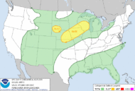
There is a chance for severe weather later today and again tomorrow. The slight risk areas are highlighted in yellow.


No comments:
Post a Comment